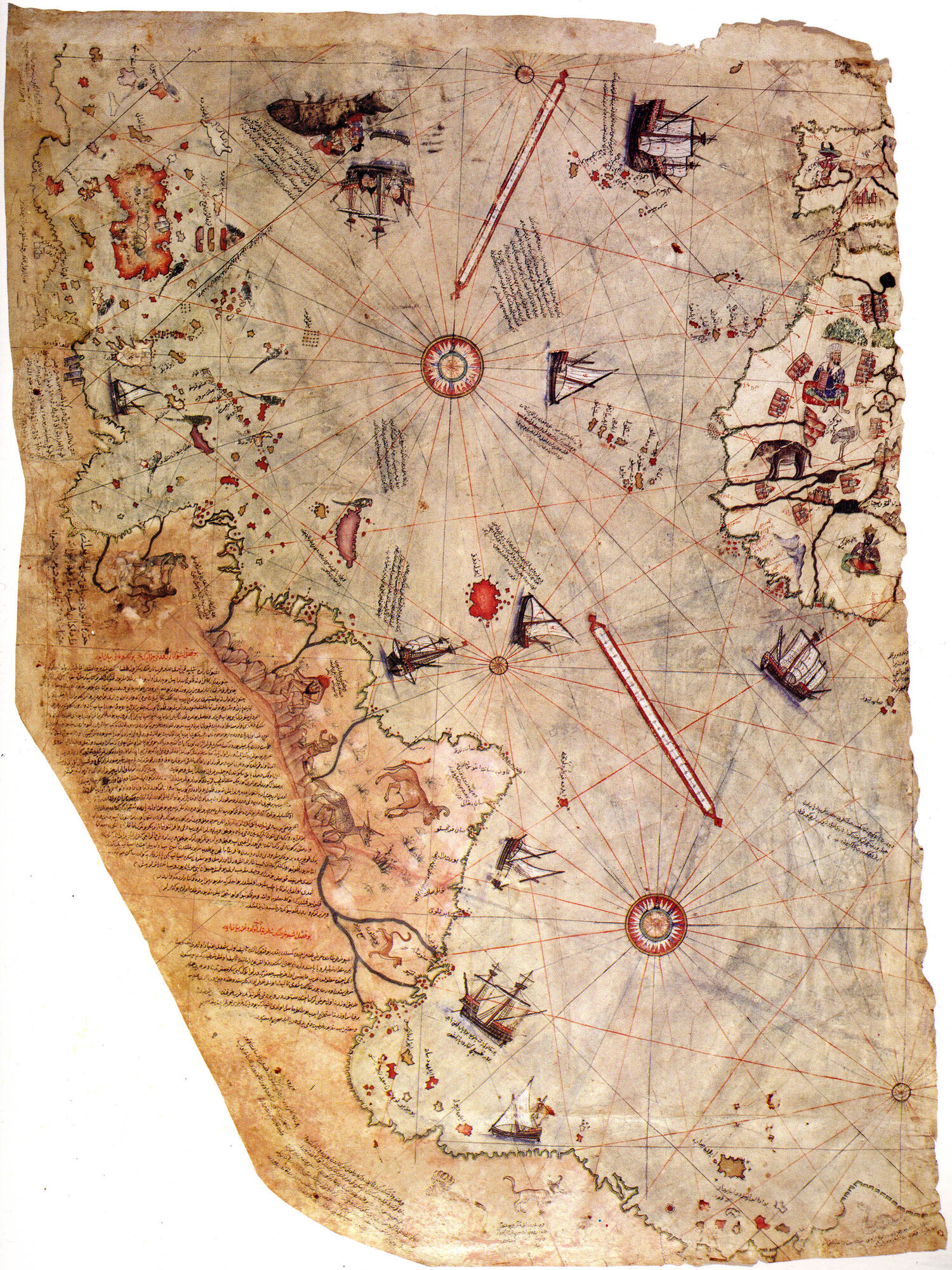
THE PIRI REIS MAP — 1513
Surviving western fragment. Drawn on gazelle skin. Topkapi Palace Library, Istanbul.
What They Knew · How They Forgot
THE PIRI REIS MAP — 1513
Surviving western fragment. Drawn on gazelle skin. Topkapi Palace Library, Istanbul.
The Admiral
Ahmed Muhiddin Piri.
Ottoman admiral. Cartographer. Nephew of Kemal Reis.
In 1513, he compiled a world map
from what he described as twenty older source maps —
some, he wrote, dating to the time of Alexander the Great.
One, he claimed, was drawn by Columbus himself.
What the Map Shows
The western coast of Africa. Accurate.
The eastern coast of South America. Accurate.
The Caribbean islands. Accurate.
And at the bottom of the fragment —
a coastline that should not be there.
Antarctica.
The southern portion of the Piri Reis map
depicts a landmass extending south from South America.
Antarctica was not officially discovered
until 1820 — 307 years later.
Its coastline was not surveyed until the 20th century.
Its sub-glacial coastline was not mapped
until the 1958 International Geophysical Year.
The Match
In 1960, Charles Hapgood — professor of history
at Keene State College, New Hampshire —
submitted the Piri Reis map to the U.S. Air Force
8th Reconnaissance Technical Squadron
at Westover Air Force Base.
Lt. Colonel Harold Z. Ohlmeyer responded:
"The geographical detail shown in the lower part of the map agrees very remarkably with the results of the seismic profile made across the top of the ice-cap by the Swedish-British Antarctic Expedition of 1949."
"This indicates the coastline had been mapped before it was covered by the ice-cap."
"The ice-cap in this region is now about a mile thick."
— Lt. Col. Harold Z. Ohlmeyer, USAF, July 6, 1960
The southern coastline on a map drawn in 1513
matches the sub-glacial topography of Queen Maud Land
as confirmed by modern seismic surveys.
The ice cap over Queen Maud Land has been in place
for at least 6,000 years.
Some estimates place full glaciation at 34 million years.
The most conservative estimate for an ice-free coast: 4000 BCE.
Not the Only Map
Three cartographers across 224 years depicted a continent
that wouldn't be "discovered" for another 83 to 307 years —
and drew its coastline as it exists under a mile of ice.
Where did the source maps come from?
Piri Reis wrote his annotations directly on the map.
He listed his sources:
Eight Ptolemaic maps (2nd century)
Four Portuguese maps
One Arabic map
A map drawn by Columbus
And maps he described as originating from
"the time of Alexander" — the 4th century BCE.
The Antarctic detail could not have come from any of these.
It came from sources older than Piri Reis could name.
The Portolan Tradition
The Piri Reis map is a portolan chart.
Portolan charts appeared suddenly in 13th-century Europe.
They are strikingly accurate.
They use compass bearings and measured distances.
They have no grid. No latitude. No longitude.
They navigate by relationship —
angle and distance between known points.
This is living geometry. Relational, proportional, navigational.
The geometry of people who could cross oceans.
124 Years Later
In 1637, René Descartes published La Géométrie.
He replaced the portolan tradition —
relational, proportional, alive —
with the Cartesian coordinate system.
x and y.
Every point reduced to two numbers.
Every curve reduced to an equation.
Every relationship reduced to a function.
What Was Replaced
| Before | After | |
|---|---|---|
| GEOMETRY | Proportional — ratios between living things | Absolute — fixed coordinates, no relationship |
| SPACE | Relational — position means something | Homogeneous — every point equivalent |
| NAVIGATION | Bearings between known points | Abstract grid overlaid on territory |
| LAND | A living system you traverse | Dead extension you parcel and sell |
| MATTER | Animated — possesses form and purpose | Inert — res extensa, stuff on a grid |
In 1641, four years later, Descartes published
Meditations on First Philosophy.
He split reality in two:
Res cogitans — mind.
Res extensa — dead matter on a grid.
Consciousness was removed from the physical world.
Land became coordinates. Trees became material.
Indigenous peoples became obstacles on unused grid squares.
The Sequence
The map is evidence.
Someone mapped a coastline that has been under ice
for at least six thousand years.
The knowledge passed through copying chains
from Alexandria to Constantinople to Piri Reis.
Then the geometry that made it possible was replaced
with a system designed to parcel and sell.
The map proves they knew.
Descartes is how they forgot.